Wednesday, March 31, 2010

Puerto Natales, then Home


The last day of the trip (not including travel days)! Another long drive from Torres del Paine to Puerto Natales, then to Punta Arenas for the flight back to Santiago. Images flash.... In the bus, Juanito (the drive), TC (trip leader) and Sergio (local guide) are passing around the mate cup. Outside, a beret-wearing gaucho chases down and ropes an errant calf. Non-native alfalfa being bailed for a long winter. Granite spires and snow-covered peaks of the Patagonian ice-field.

We reached Puerto Natales mid-morning in time for a coffee and hot chocolate refreshment. The town reminds me much of Kodiak Island, Alaska; quiet and charming.

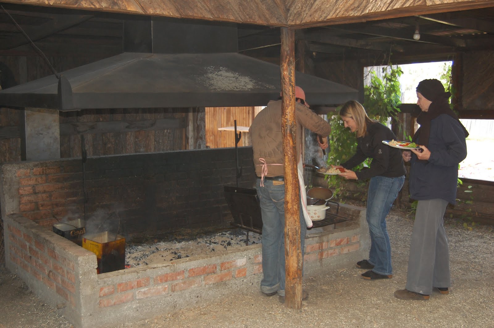
Almost to Punta Arenas, we stopped at an estancia for an asado (traditional barbeque). The food was fine, but I wasn't thrilled that the owner had turned his property into a kind of zoo to show tourists, keeping otherwise wild animals and birds in cages. They also gave us a sheep-shearing demonstration, which I could have done without. Watching a terrified sheep lose its coat has no appeal!

In Patagonia, ranchers have have been raising sheep for the last 100 years. Now, their big market is China. But sheep hooves are very damaging to the soil, making it harder for the wild animals to survive. In contrast, the native guanacos have soft padded feet that tread lightly...

Outside Puerto Natales for the first time I saw plastic bag pollution, with hundreds of plastic bags caught in stunted deciduous beech trees. Until then, I had seen not a one plastic bag littering the landscape. I noticed that no one gave plastic bags - even when I asked for one to cover a book I would be putting in my suitcase. Didn't have them. I asked about the pollution issue, but no one seemed to know. I think they realized a long time ago that wind and plastic bags don't mix.

Tuesday, March 30, 2010

Goodbye Torres del Paine


After such a brutal walk in the wind, we had the option the next day of easy hiking with the whole group, or a challenging 6-8 hour round trip jaunt up to the base of the spires of Paine (for which the park is named). Only Jenny and I chose the hard way. We went with a local guide, leaving for sunrise (which, granted, was at 7:45 a.m.) and beating the crowds which flock to the park for this very hike. It wasn't too steep until the last scramble up the boulders of the terminal moraine (that's glacier-speak) to look down on the glacial lake as the base of the spires (see photo). It was worth it, however, and we were entertained with stories of climbing the spires by our local, rock-climbing guide. It was freezing up there, even in the bright sunshine, and I couldn't imagine trying to cling to a rock face while my hands went numb!

Reflecting on the trials of the trip, we realized how lucky we had been with the weather in this unpredictable part of the world. We were never caught in real rain, or forced to change plans because of weather. While we wore our rain gear every day it was more for the wind than threat of rain. It seemed like a ray of sunshine was following us....

El Viento (The Wind)


We finally crossed into Chile for the last couple days of the trip at the National Park of Torres del Paine. Blustery rain pummeled the estancia where we were staying all night, but we awoke to bright sunshine... with howling winds. This was the day we would learn about the winds of Patagonia! Our group again split into 2 groups, and the same 3 of us braved it for a 5 hour hike through spectacular scenery, while the remainder were grounded lest they be blown away. I have never been in winds like this - the kind that literally blow you off your feet. We all stumbled, like we were drunk, down the narrow trail, but were rewarded by the views. We saw some clown-like Austral parakeets being blown about, but the wildlife was otherwise hunkered down, letting the wind pass.

Sunday, March 28, 2010

Patagonian Steppe

On the second day in El Chalten, 3 of us donned crampons and did a glacier hike, which gave us a whole different perspective on these massive ice fields. It wasn't raining, but it was COLD, maybe the coldest day so far (see photo below. Yes, I wore my Peruvian alpaca hat everyday. Not that cute, but very warm!) To get to the glacier, we took a boat across the glacial lake, and got up close and personal with some recently calved, very blue icebergs.

After El Chalten, we drove south again past El Calafate, back towards Chile. It was a long day over the brown Patagonian Steppe, but the advantage to being in a private vehicle is the ability to stop anytime to look at wildlife, birds, scenery or just to have coffee at a converted estancia.


We were all pretty interested in birds, so no one minded if we stopped for 20 minutes to photograph a rhea (flightless bird - see photo above) or an eagle. Also above: a herd of guanacos stops grazing to look at us. They are related to the llama.

El Chalten & Mt. Fitzroy


Above: Sunrise on Mt. Fitzroy

Disaster. The afternoon that we arrived in El Chalten, base for exploring Mt. Fitzroy, I started to feel queasy. As I lay in my hotel room waiting for the inevitable, I summoned all my will to make the virus pass as quickly as possible, since our first hike of the trip was the following day. I also willed the weather to clear as it was pouring rain, combined with fierce winds - if it didn't clear, the hike wasn't going to happen. I drifted in and out of sleep for the next 14 hours, but woke in the morning feeling okay, able to eat a little, and happy to see clear skies! A total of 5 of 7 in our group caught the virus, but I only missed one dinner (whereas most people were out for 2 days), which I attribute to my very fast metabolism. Out out damn virus!

The hike split into 2 groups, with me, Jenny and one of the retirees taking the long route with the local guide. This turned into a marathon, 15 mile hike, up and down in the glacial valley below Fitzroy. Somehow I willed myself to finish, but wasn't feeling my strongest, to say the least! The hike was beautiful though, and we had fun spotting all the different birds, including the Magellenic woodpecker, a foot-tall, redheaded joker who had eluded us until then.
Below: Sunrise over El Chalten. Sunrises in this part of the world are amazing!

Saturday, March 27, 2010

Senor Perito Moreno


El Calafate has grown out of nothing to serve as the base for the hordes of tourists coming to see perhaps the most famous glacier in South America, the Perito Moreno Glacier. We saw many glaciers, but this was the granddaddy, the most blue, the most awe-inspiring. It is one of the few glaciers that is still advancing, at the rate of a meter a day. And when the ice hits the water and breaks off ("calves"), the thundering roar brings all to attention.

Perito Moreno brings so many visitors, the government constructed a series of railed walkways across from it for safe viewing. I think people were going right down to the edge and getting occasionally getting crushed by an errant iceberg. After scaling all the walkways in the bitterly cold wind, we hopped aboard a boat to get a view from the bottom - the boats keep a safe distance, but being down on the glacial lake gives you a wholly different perspective of the glacier.

Back at El Calafate that evening, a stomach bug that one person had on the ship claimed a third victim (3 out of 7?! I hope it doesn't make it to me!), which was too bad, since we were continuing to enjoy excellent food. The advantage to being in a tourist center was a proliferation of quality restaurants. I was a little beefed out and had homemade gnocchi. Yum! After 3 days in Argentina, from what I could figure out, the food is all about pizza, pasta, beef and dulce de leche. I can think of worse things!

On to Argentina


On Wednesday morning our ship docked in Ushuaia, Argentina. Ushuaia is on the little dislocated piece of Argentina in the very south, on the main island of Tierra del Fuego. The islands of Patagonia known as "Tierra del Fuego" (Land of Fire) were so named by the first European explorers because when they sailed through the channels, the land was engulfed in smoke from the fires of the natives. Today, nothing remains of the native culture, having been entirely wiped out by the Europeans in a matter of years.

A note about the Mare Australis before we leave her: I can't recommend it enough for anyone interested in Patagonia. The rooms were comfortable and extremely clean and well-maintained, the staff was knowledgeable and helpful, and the food - ah, the food. I have never willingly eaten so much steak, but they really had the best of the entire journey, cooked perfectly - kind of melt-in-your-mouth. There was also king crab night, where I finished 3 plates of those who didn't want theirs (weird!), a Chilean specialty buffet lunch.... and scrumptious desserts. I think we all gained a few pounds aboard.

After a early departure from the ship and a short walk through Tierra del Fuego National Park, we boarded a plane headed north for El Calafate, Argentina. Between the lush coastal forests of Southern Patagonia and El Calafate (which is located at the foot of the Argentinian / East side of the Andes), we crossed the dusty brown expanse of the Patagonian Steppe, another one of the 4 distinct areas of Patagonia. On this flight I could really see how Patagonia is one of the least populated places on earth.

Above photo: Ushuaia looks a lot like Alaska, doesn't it? The comparisons were everywhere, and I am sure the guides get tired of hearing it!

Friday, March 26, 2010

Avenue of the Glaciers


On the second to last evening aboard the Mare Australis, cruising through the Beagle Channel, we passed through what is called the "Avenue of the Glaciers." The channel runs along the south side of the Darwin Range of mountains - a range completely in Tierra del Fuego, and not part of the Andes which contains a giant ice field that can be seen in the glaciers that hang down the valleys of the range. One after another, massive glaciers came into view as we cruised along, our ship accompanied by albatross, petrals, terns and cormorants - flying with purpose back and forth across the channel.

The channel was named after the HMS Beagle - the ship carrying a young Charles Darwin on his now famous journey to South America in the 19th century. He actually spent more time in Patagonia than the Galapagos Islands, and documented much of the unique flora and fauna of this extreme land.

Tuesday, March 23, 2010

Isla Hornos


One of the highlights of the boat portion of the trip was the opportunity to visit Isla Hornos, or Horn Island, which is where the legendary Cape Horn is found: the southernmost point of South America, often referred to as the end of the world (where one unlucky Chilean sailor and his family are stationed). The ship always tries to visit, but actually landing the Zodiac boats is very weather and sea condition-dependent. As you can imagine, the area of ocean where the mighty Pacific meets the Atlantic can be a turbulent place.

The morning of the planned landing we woke to 6 foot swells and all of us thought a landing was out of the question. However, as we neared the island the sea calmed and the crew hastily readied everything for our visit ashore. We were so lucky, as the sea stayed calm for a couple hours as we hustled to the island and back. I stayed as long as I could at the lookout facing the actual cape (see photo). It was an unearthly place; many people remarked on it being a spiritual experience to visit this remote island.

Top photo shows me with Cape Horn in the background. Yes, it was cold!

Monday, March 22, 2010

Penguins and Elephant Seals


Our first day on the Mare Australis brought us to Ainsworth Bay and Tucker Island, blips in the maze of Southern Patagonia, where wildlife thrives in the freezing wind and water.
At Ainsworth Bay, a couple young male elephant seals were resting and we were lucky enough to snap a few photos. They would be the only ones we saw up close on the trip (there are large colonies on the Atlantic coast, which we didn't visit.) The naturalist guides led us on a short walk to explain the unique flora - many small shrubs, mosses and deciduous beech forests.
The afternoon excursion was by Zodiac boat to Tucker Island, home to a colony of Magellenic penguins and numerous rock cormorants and king cormorants. I was glad that the passengers were not permitted to exit the boats, and we were limited to snapping photos from the shore. The penguins were not shy at all, and didn't seem bothered by our presence. Looking at the peaceful, goofy birds, it was hard to imagine that 200 years ago, crews from ships passing though would club thousands of them to stockpile as meat on board.

Sunday, March 21, 2010

The Mare Australis


After a quick tour of Punta Arenas, we boarded the Mare Australis, a 100 passenger, luxury expedition/cruise ship which would take us through the channels, fjords and islands of Southern Patagonia, to Cape Horn and finally to Tierra del Fuego. The ship was not what I think a standard cruise ship would be (having never been on one), as there were no parties, no hot tub or pool or other on-board diversions. Instead, there were lectures and films on the history, glaciology, flora and fauna of Patagonia. Trained naturalists took us on excursions via Zodiac boat to glaciers and islands. The staff was excellent and professional and tried to make sure that each guest had a good experience - an enthusiasm I didn't expect at the end of the season from a crew dealing with 2 new groups of tourists each week.

What I saw was a wild, uninhabited and beautiful place at the end of the world. I felt very lucky to be there.

Above photo: Sunrise aboard the Mare Australis.

Friday, March 19, 2010

History Repeats


Like the frontier towns of Alaska, Punta Arenas was built up in the late 1800´s, and shares the same feel of Anchorage: straight grid streets with ocean views, slanted summer light of an extreme latitude, and that certain grittiness of a hard life.
Even though many of the surviving buildings date from the late 1800's, the area of Punta Arenas was being used as a port for a couple hundred of years before that, being at the western end of the Straight of Magellan, and the primary port of call for ships after rounding Cape Horn.

Almost 15 years ago I read Two Years Before the Mast, Richard Henry Dana's harrowing account of making the trip from Boston to California in 1830 aboard a wooden two-masted schooner, and his account of trying to sail around Cape Horn - and the extreme winds and rough seas - stayed in my mind ever since. There is something mythical about it - but more on that later. Punta Arenas was our port for boarding the Mare Australis, the ship that would take us through the fjords and islands of the Beagle Channel to Tierra del Fuego.

Santiago: Business As Usual?


Mercifully, I was able to finagle an upgrade to business class for my flight down to Santiago, and my injured back tolerated the 15 hours without pain. I had a day in Santiago to meet up with my group and have a city tour before flying to Punta Arenas in the south.

Walking around the many pedestrian streets, it appeared that life was back to normal for many Chileans. It is nearing the end of summer, and the people were out enjoying the sun, eating gelato, and, it seems, enjoying a smoke (there seem to be a lot more smokers in Chile than the other places I have been recently). One day in Santiago was not enough though, and I have resolved to come back and see more of this very modern city.

As I mentioned, for this trip, I joined an organized group. It is not my preference - I like going it alone, but seeing Patagonia on one´s own, via public buses required a lot more time than I wanted to spend (the region is mostly uninhabited). Mountain Travel Sobek has been running trips to Patagonia for 20 years, so I knew I would be in good hands too. The group consisted of 5 seniors (over 65), and Jenny (37) - a recovering investment banker from NYC who is traveling for awhile like me. A good group!

Hello Patagonia!

I am on the last day of my trip to Patagonia, waiting at the Holiday Inn in Santiago for my overnight flight home. I decided that I had better start my blog entries for this trip!

Patagonia is a region of South America that covers part of Argentina and part of Chile, starting around latitude 40 degrees south, then south from there to the tip of South America. Patagonia has unique flora and fauna, and incredible winds, being the only land mass on the planet at that latitude (it is even more south than New Zealand!). There I would see some amazing things: penguin colonies, elephant seals, glaciers calving building-sized icebergs, flightless ostrich-sized birds, the Patagonian Ice Field (the 3rd larget fresh water reserve on earth) and Cape Horn - the end of the world.

The whole trip was put into question when 5 days before my scheduled departure to Santiago, Chile suffered an enormous earthquake. The city of Santiago was spared too much damage, but the airport was temporarily shut down due to structural damage. They were soon up and running again, out of tents on the tarmac (see photo), and I was able to leave as scheduled, arrive in Santiago and fly out again to Punta Arenas, in the south. As of today, almost 3 weeks after the earthquake, the Santiago Airport is still operating out of tents on the tarmac, but everyone is being very patient and nice, and are doing the best they can to get the airport repaired. (The Holiday Inn itself suffered enough damage to render the elevators inoperable, and put cracks in all of the walls).

Although I am starting this leg of my blog at the end of trip, I hope you follow along as I relate my thoughts and experiences on this incredible trip!