Sunday, November 29, 2009

Coming Home


Sitting at the Quito Airport, waiting for my Continental Airlines flight to Houston, I think I have never been so excited to come home. Even at the end of my Asia journey, despite the heat and time and distance, there was a little sadness in leaving. Not so today – I am looking forward to getting back to my own poochies, the ones at the Humane Society, and of course, the ones I love (you know who you are!!)

The week in the Galapagos was magical, but not in the way I thought it would be. The islands are volcanic (young ones at that, in Earth-formation-time), and you would think that they would be all lava rock, speckled on the edges with bumpy black marine iguanas, blue-footed boobies and sea lions. But the slopes of the distinct volcanic cones are lush with cloud forests and ferns, and populated with all manner of wildlife.

Saturday, November 28, 2009

Galapagos


Just back from the Galapagos Islands! Here are a few photos, words will follow later.

Sunday, November 22, 2009

Orchids and Fog


Today was an excursion to the El Pahuma Orchid Reserve and Pululahua Reserve – an extinct volcano crater which is inhabited and farmed. We got there just before the daily curtain of fog rolled in and filled the crater, obscuring the view.

At the orchid reserve, my guide showed took me through all the different species of orchids that grow in the temperate cloud forest, as well as a lot of the other amazing plants (see the photo of the elephant’s ears!) These cloud forests fit in between the highlands and the Amazon jungle and have wholly separate ecosystems and plants from the other areas, making the for a dizzying array of species in this small country.

Tomorrow I am off to the Galapagos Islands, 600 miles to the west of Ecuador in the Pacific Ocean. I will be without my computer, and possibly without internet at all, until Saturday night, so no updates until then.
Have a great week!

Saturday, November 21, 2009

Don't Be Lazy, Don't Steal, Don't Lie


Those three commandments are from the Inca, and I think they cover the essentials. Can you imagine if everyone in our society followed them?

I am relieved to find myself back in Quito, after 2 days on the grey, clouded in coast. Montanita was not my scene. I can imagine it gets quite crowded during the surf season, and that the parties rage all night.

Tomorrow I am off to the cloud forest, for a hike in an ecological reserve. Just me, my guide and the flowers; I think that’s more my speed!

Back to the Pacific


After a rainy day browsing Incan ruins outside of Cuenca, I took a short flight to Guayquil, then a car to reach Montanita, on the south-central coast of Ecuador. On reaching the Pacific, I realized that I hadn’t seen the ocean in a month! However, I was greeted by onshore winds that put a mushy crumble on the little (1-1 ½ foot) swell that was in the water.

I had chosen Montanita to sample the Ecuadorian coast for a couple days – it happens to be the epicenter of the Ecuadorian surfing scene. If I could get in a surf, it was most likely in this place. It turned out to be a backpacker haven, although I have a hard time understanding this since the prices are 30% higher than elsewhere in Ecuador (which are already high in comparison to other similarly situated countries). Every other shop has the word “surf” in its name, the streets are lined with bars and restaurants catering to foreigners, and sunburned gringos with dreadlocks have set up tables displaying cheap trinkets for sale.

The surf breaks themselves are a beach break (described as tolerable in my Lonely Planet) and a right point (that happens to be right outside my hotel room). Unfortunately, today the wind made such a mess of things, I couldn’t get motivated to get in, despite the hoards of enthusiastic beginners taking a turn in the slop ( I also noticed that most of the locals were wearing fullsuits…), and a trio of enthusiastic sea kayakers. For those you from San Diego, think Pipes on a blown, overcast day…..

Wednesday, November 18, 2009

Counting


A wave of homesickness hit me last night, together with the rain that poured in through the decrepit taxi’s window (I left it open to air out the gasoline fumes filling the car). My “traveler’s Spanish” has been exhausted, and I feel bad that I have not spent the time to learn Spanish properly. My well-intentioned resolutions to go home and study Spanish always seem to evaporate quickly after I return home from a Spanish-speaking country. Another stomach bug – Ecuadorian version – has found me too, which has not helped matters any.

Yesterday I went with a guide and one other tourist to Cajas National Park, not too far outside Cuenca, but a world away from city influence. This is a huge watershed area, blessed with hundreds of lakes, that provides Cuenca’s water supply. It feels pristine, thanks to aggressive conservation efforts by the city’s water department, which runs it. “Cajas” means cold in Quechua (local language), and indeed the area lived up to its name after the clouds rolled in and the rain started.

I fly home 11 days from now, and although I have the Galapagos Islands yet to come, I am looking forward to getting back among familiar faces.

Monday, November 16, 2009

Cuenca


Situated in a valley in the Southern Ecuadorian Highlands, Cuenca is a colonial gem – a UNESCO World Heritage site since 1999, but dedicated to preservation for 20 years prior to that. I booked a private afternoon city tour, which took me to the many churches (the oldest one is 470 years old), streets and boulevards and colonial mansions preserved in the city. Cuenca is a relatively progressive: cockfighting and bullfighting (so popular throughout Ecuador) are banned here, there are 6 universities (for a city of 450,000), and there are plans to shut down the downtown streets and install trams.

Cuenca is also the leading center for fabrication of the Montechristi hat (known to most of the world as the Panama hat). It got that designation after newspapers around the world published photos showing workers on the Panama canal wearing them (they had been imported from Ecuador for the workers). But it turns out that the reed used in their construction can only be grown on the coast of Ecuador, and so they are still only produced in Ecuador despite the misnomer.

While I was afraid that my time in Ecuador would be all rain, it has been warm and sunny since Friday. Good weather for me spells continued drought for Ecuador – a country that relies on the flows of its rivers for hydro-electric power. As a result, there have been rotating blackouts everywhere (save the big hotels which have their own generators).

Volcanoes


I am back in Quito, but head off to the southern colonial gem of Cuenca this afternoon. This last weekend, I stayed in one of the many restored 17th-century haciendas, complete with stables, enormous fireplaces and huge-beamed ceilings. The hacienda style of architecture, with a tiled courtyard and fountain in the middle of the sprawling white-washed house has always been my favorite, and I fell in love with the hotel. Well, really all of Ecuador is just lovely.

Like in Bolivia, the valleys of the Ecuadorian highlands are surrounded by volcanoes, ranging from 12,500 to 15,000 feet. Here, as in Bolivia, the glaciers on these are shrinking at an alarming rate. We spent the morning hiking up around a crater lake on the shoulder of one of these extinct volcanoes (Cotacachi), which afforded fantastic views across all of Otovalo valley. On the drive back we were confronted with the very clear view of Cotopaxi – another volcano close to Quito that remains hidden behind cloud cover much of the time.

Sunday, November 15, 2009

Otovalo Snapshot


Otovalo is in a large valley, sprawled out between 4 extinct volcanoes, each one with a distinct, different personality (as believed by the locals). Even though the altitude is close to 9,000 feet, the valley is green and lush, as are the hillsides leading up to slumbering craters.

My guide and I arrived here after a stop at the official equator – 0 degrees latitude. It turns out that just last month he made a trip to Bolivia, following much the same route as me, and has been able to assist in my comparisons of these two very different Andean countries. Even though the Andes reach in Venezuela, Chile and Argentina, the “Andean culture” of the high mountains (think panpipes, llamas, and alpaca sweaters in geometric designs) is limited to the countries of Peru, Bolivia and Ecuador. I feel that the latter two are extremely different, but it is hard to quantify at this moment. I invariably draw the comparison that Bolivia is to Ecuador what Burma is to Thailand – sharing similar cultures, religions, roots and ancestors, but one being far more advanced than the other.

The local people of local people of Otavalo have a very interesting traditional dress that has clearly borrowed from European influences over the last 500 years since the Spanish arrived. Men and women wear espadrilles on their feet and fedoras on their heads, both with a long single braid of jet black hair down their backs. Women wrap multi-stranded gold beads around their necks, and coral colored beads around their wrists and don lacy embroidered blouses and long wool skirts topped with embroidered sashes. Men favor cropped , light colored cotton pants and solid blue wool ponchos. Smiles are ready.

Today I infused my share of American cash into the Ecuadorian economy, buying several rugs, a couple paintings (on goatskin no less), a Panama hat (such hats originated in Ecuador – did you know that?), some panpipes and other typical Andean souvenirs.

Friday, November 13, 2009

Quito


Farewell, Bolivia. Yesterday I hopped two flights over from La Paz to Quito, landing among clouds and sprinkles, but at just under 9,000 feet above sea level, the climate is much more mild than what I had been experiencing in Bolivia.

My first impression led me to compare this capital city with La Paz (which is actually not the real capital, but a kind of de facto capitol). Less crowded, by far, even in the old town with its one way streets and cobblestones. More diversity – people of various heights and hair color, perhaps indicating more European descent. More people seem to speak English. I read that one in 10 Ecuadorians lives and works outside the country, meaning almost everyone has a relative outside Ecuador (in the U.S. or Europe), and I think this may lead to a greater awareness of the world outside their country, even if they have never been.

Today I head north (and down) to the Otovalo area for the weekend, which hosts a large weekend market, and I will get to see a lot of the countryside. I already feel that there is a huge contrast between Ecuador and Bolivia – I guess this was one of the reasons I chose them (instead of 2 contiguous countries). It will be interesting to find out more……

Tuesday, November 10, 2009

White City


Butter cookies of all shapes and sizes, multi-layer white cakes with swirls of whipped frosting and candied fruit, butter-laden biscuits, French rolls, candies. Bolivians sure love the sweets! I gain 5lbs just looking at all them in the market and the shop windows….

Sucre (La Ciudad Blanca de Las Americas) is a bustling, relatively modern city (and is the capitol of Bolivia), dating from 1538 when the Spanish established it as an administrative center for its colonies in Bolivia, Argentina and part of Peru. The buildings in Sucre are even more well preserved and orderly than Potosi, and the city was also declared a UNESCO World Heritage Site in 1991. At a mere 9,000 feet above sea level, the weather is warm and dry – mid 70s – a welcome relief from the brisk to frigid air of the last 3 weeks.

I arrived via car from Potosi, driven by my guide for the day. Such a nice alternative to the bus, even for 160 kilometers! I wish I had a couple more days here to enjoy the weather, but Ecuador calls, so I am off to La Paz tomorrow and Quito the day after.

If anyone is reading this, feel free to leave me a comment!

Monday, November 9, 2009

Highest City in the World

Tomorrow marks the anniversary of Potosi’s independence, and today the streets were filled with parades of marching bands from all of the schools in the area. Tomorrow will see even more festivities…. The parades, together with mild, warm weather brought everyone to the streets, which were mostly closed to cars, so it was a good day for strolling the streets. I had a brief city tour, but as the guide spoke little English, I found my guide book and self-touring more informative.

Founded in the mid-1500’s, Potosi was a jewel in Spain’s colonial crown at the time, growing to be bigger than London or Paris of that time, and sending home tons and tons of silver to fuel Spain’s colonial ambitions. Unfortunately, the conditions of the indigenous miners extracting that silver from treacherous mines resulted in approximately 7 out of 10 dying one way or another. The silver boom lasted about 100 years before the claim ran out and the city went into decline. The mines are still plied for tin and other minerals, but apparently the conditions for the miners have changed little. The life expectancy of a miner is about 35 years.

One of the de rigueur tourist experiences in Potosi is donning hard hat, coveralls and headlamp and visiting a working mine. Get your photo taken all made up like a real miner! But somehow I can’t bring myself to be a tourist to suffering, and I have eschewed the experience.

Nonetheless, I have enjoyed the city and found a great restaurant that serves some great vegetarian food, in addition to the standard llama or pollo a la plancha. Salad, vegetables, whole wheat bread! It’s funny how much happier I feel when I am eating healthy food. I am looking forward to a reduction in altitude (the next city is at less than 9,000), as the bright sun, dust, and altitude are taking their toll on my eyes and sinuses. My nose is red enough to suppose that I have been swilling Scotch instead of agua mineral.

Plastic Flowers

Greetings from Potosi, the highest city in the world at 12,300 feet above sea level. The city was founded by the Spaniards in the mid-1500’s after a major silver deposit was discovered here. Declared a UNESCO World Heritage Site in 1987, it has the best collection of Spanish colonial architecture in South America.

I was fortunate enough to get a car ride from Uyuni to Potosi with my tour company – only 3 ½ hours. The other option was an all day, 6 hour bus ride, which I was glad to avoid. Leaving Uyuni, a dusty crater of a town on the edge of the salt flat, all I could see were plastic bags stuck in the scrappy shrubs, at least one bag per, giving the landscape the appearance of having grown these black and white plastic flowers. Seeing this, I remembered what my guide had said on day one: that there is a plague that is upon all of South America – plastic. I told him it wasn’t confined to South America....

Even by Bolivian standards, the landscape on the drive to Potosi was stunning. We started in desert which looked much like the American Southwest, with pink-blooming cacti and tiny green shrubs, then into a lunar landscape of strange rounded hills in hues of green, purple and red (the whole area is chock full of minerals). From there, it was giant sand dunes, studded with thorny green shrub-trees and coarse grasses, before we finally passed into the red-rock barren landscape of Potosi. Almost of all of these various settings are marked by the tall, distinct forms of llamas out to graze (they are all domesticated).

Today I have a city tour to admire the architecture, then tomorrow I am off to Sucre, the capitol of Bolivia for one night before flying (thank god) back to La Paz.

Note: the photo shows my guide picking up plastic trash on the salt flat.

Sunday, November 8, 2009

Salted

November 6, 2009


After a cold night, we set out across the Salar de Chiguana, a smaller salt flat south of Uyuni. White and desolate, it is surrounded on all sides by the brown peaks of extinct volcanoes, and the red and white peak of one active one. The road was rough and tumble as we headed north – in fact all the roads in the southwest (which are exclusively dirt) share the same characteristic: consistent washboard caused by all the Toyota Landcruisers going full speed across them. As the drivers try to avoid the washboard they have created, they carve out more and more roads on either side of the existing roads, severely damaging this fragile environment.

We saw many more lagunas, complete with flamingos, sticking it out in the icy wind. At the Salar de Uyuni, the scene completely changed. It is 10,000 square kilometers of solid (or nearly solid) salt, thick enough at this time of year to drive across. Geologists believe that there was once a massive lake here that evaporated, leaving behind the salt deposits. There is still water below the 10 cm thick salt crust, which is the cause of the polygonal shapes on the surface (see photo).

A word about the food…. For those who followed my blog while I was in Asia, you know that I get very excited about trying new cuisines. Bolivia has not provided much excitement. The basic fare is a piece of meat (maybe llama), chicken, or, closer to Lake Titicaca, fish (trucha), accompanied by rice and potatoes. I think I have eaten more red meat in the last 2 weeks than in the last 4 years. If a vegetable finds my plate, I am ecstatic. The local people often use salsa picante to spice up this bland assemblage, but it usually isn’t offered to tourists. All the white rice and potatoes is accompanied by lots of soft white bread (served for breakfast, an with lunch and dinner). I have confirmed that this is typical Bolivian fare – not just the tourist menu. Sigh. At least I am not in danger of gaining any weight on this leg of the journey; I usually lose interest in my meal before I finish it.

Dust to Dust

November 3, 2009
After ½ a day in La Paz, I once again hit the road to see more of Bolivia. First, there was a 3 hour bus ride due south, no stops, with an American horror flick dubbed in Spanish playing at full volume. It was the oddest choice for a bus full of gringo tourists and local Bolivians.

The ride was flat across the Altiplano, looking much like the American Midwest, except that all the houses were made from mud-adobe brick. This is one of the enduring images of Bolivia, even though only 35% of the country is Altiplano; most of the country lies in the sub-tropical and tropical zones, and includes a large portion of Amazon jungle.

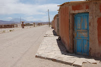
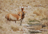
After finding my way through a couple dusty towns that looked for the most part like they had been bombed and left, I set off with a guide and driver across the Salar de Uyuni (salt flats) and into the Reserva Edoardo Avaroa, an ecological reserve in the southwest corner of Bolivia, near the border of Chile. This is a vast area of arid high desert, some of it so desolate that it reminds one of Mars or the moon (except that periodic springs appear from the earth, creating grassy oases for man and animal alike). A hardy relative of the llama – the vincuna – lives here, nibbling on microscopic grasses. 
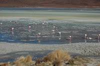
There are also a lot of birds – most notably, the flamingos (3 different types), which favor the large salty “lagunas” (very shallow depressions that catch a bit of water) scattered throughout the area. Sadly, the lagunas are slowly drying up – attributed to global warming – and may be gone in as little as 30 years.

The one constant feature of the entire trip south has been the fine dust that works its way into everything. Coupled with vicious afternoon and evening winds, the dust has become part of my wardrobe.

The first night we stayed at a rustic guesthouse in a little settlement, which was built right up against the rock, with walls of rock and adobe, and straw insulation for ceilings. The icy wind howled all around us, it stayed pretty warm despite below freezing temperatures (we found solid ice on all the streams in the morning).
The second night we stayed at a brand new rock and mortar hotel constructed truly in the middle of nowhere. It was actually quite nice – the nicest place I have stayed since leaving La Paz! They are relying on the tourists who visit the reserve for both an income and entertainment, I suspect, as it is a very lonely existence.

Monday, November 2, 2009

The Well of Recovery


On arriving at La Senda Verde, I wasn’t sure I wanted stay at all, much less 2 nights. It was hot. There were bugs. I was sick. Also, being a wildlife refuge first, guesthouse second made it not an ideal location for recovery. However, after a surprisingly deep 10 hours of sleep (despite the sounds of the jungle invading my thatched-roof cottage), I woke 75% recovered, and with a new perspective on things. I made friends with an Australian girl traveling basically the same route as me, and we did a little stream scramble up to a refreshing grotto, where I felt my recovery much advanced.

While I feel like I hadn’t signed up for such a rustic detour, I have to admit that I enjoyed the break from the arid heights of La Paz and the Altiplano. Damaged sinuses recovering. The refuge, a private facility, was full of animals and birds brought by SOS – the animal rescue agency of Bolivia, in addition to a great collection of dogs owned by volunteers and the proprietor.

Welcome to the Jungle

Almost unwittingly, I find myself back in the jungle, slathering on the 40% DEET, staring at a thatch roof, wondering what little bugs will invade my space tonight.

I had limited choice of accommodation since it was a holiday weekend, so I ended up at La Senda Verde - a wildlife refuge with guesthouses. The area had been described as "sub-tropical", lying at 3,000 feet above sea level, but it sure felt like jungle to me, complete with monkeys, screaming parrots and mosquitoes. This is not really what I had in mind... I really felt like I had enough of the jungle in SE Asia.

La Senda Verde is in Yolosa, which has the distinction of providing the endpoint to the World's Most Dangerous Road. Unfortunately, my mountain biking adventure down that road didn't quite turn out as planned. The morning of, at about 2 a.m., I woke to severe stomach cramps, which continued through the early morning as I got sicker and sicker. I debated staying in La Paz, but that would mean missing my chance to see this other, different part of Bolivia, so I sucked it up and started the ride. I made it only a third of the way down before I decided to jump in the sag wagon, so weak I felt. Nonetheless, I was able to take in some spectacular scenery, and descend from the Altiplano for a break in altitude.